 |
|
Relevant publications |
|
|
|
Abstract |
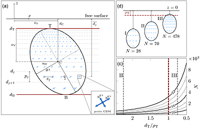
We develop quasi-analytical solutions for the surface deformation field and gravity changes due to the pressurization of a finite (triaxial) ellipsoidal cavity in a half-space.
The solution is in the form of a non-uniform distribution of triaxial point sources within the cavity. The point sources have the same aspect ratio, determined by the cavity shape,
while their strengths and spacing are determined in an adaptive manner, such that the net point-source potency per unit volume is uniform. We validate and compare our solution with
analytical and numerical solutions. We provide computationally efficient MATLAB codes tailored for source inversions. This solution opens the possibility of exploring the geometry
of shallow magma chambers for potential deviations from axial symmetry..
|
|
|
 |
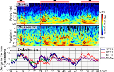
Detecting Volcano-Related Underground Mass Changes With a Quantum Gravimeter
Laura Antoni-Micollier, Daniele Carbone, Vincent Ménoret, Jean Lautier-Gaud, Thomas King, Filippo Greco, Alfio Messina, Danilo Contrafatto, Bruno Desruelle
▶
Geophysical Research Letters, Volume 49, Issue 13 (2022)
|
|
|
Abstract |
We present the world's first time series acquired in the summit area of an active volcano with an absolute atom interferometry gravimeter. The device was installed
∼2.5 km from the active craters of Mt. Etna volcano and produced a continuous high–quality gravity time series, despite the unfavorable environmental conditions at the
installation site and the occurrence of phases of high volcanic tremor during the acquisition interval. Comparison with data from superconducting gravimeters installed
elsewhere on Mt. Etna highlights correlated anomalies, demonstrating that the quantum device measured gravity variations driven by bulk mass changes. The latter are
reflective of volcanic processes, involving the dynamics of magma and exsolved gas in the upper part of Mt. Etna's plumbing system. Our results confirm the operational
possibilities of quantum gravimetry and open new horizons for the application of the gravity method in geophysics.
|
|
|
|
|
|
Abstract |
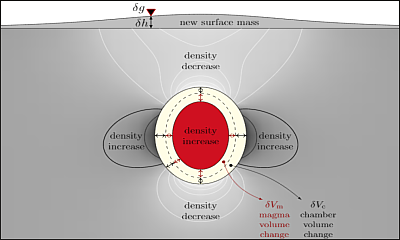
Volcanic crises are often associated with magmatic intrusions or pressurization of magma chambers of various shapes. These volumetric deformation sources dilate the country rocks changing
their density, and cause uplift. Both the net mass of intruding magmatic fluids and these deformation effects contribute to surface gravity changes. Thus, to estimate the intrusion mass
from gravity changes the deformation effects must be accounted for. We develop point-source analytical solutions and computer codes for the gravity changes caused by triaxial sources of
expansion. This establishes fully coupled solutions for joint inversions of deformation and gravity changes. Such inversions can constrain both the intrusion mass and the deformation source
parameters more accurately. In the absence of vertical displacement data, gravity changes together with horizontal displacements can be inverted to retrieve both the intrusion mass and the
deformation source parameters.
|
|
|
|
|
|
Abstract |
Volcanic crises are often associated with magmatic intrusions or pressurization of magma chambers of various shapes. These volumetric deformation sources dilate the country rocks changing
their density, and cause uplift. Both the net mass of intruding magmatic fluids and these deformation effects contribute to surface gravity changes. Thus, to estimate the intrusion mass
from gravity changes the deformation effects must be accounted for. We develop point-source analytical solutions and computer codes for the gravity changes caused by triaxial sources of
expansion. This establishes fully coupled solutions for joint inversions of deformation and gravity changes. Such inversions can constrain both the intrusion mass and the deformation source
parameters more accurately. In the absence of vertical displacement data, gravity changes together with horizontal displacements can be inverted to retrieve both the intrusion mass and the
deformation source parameters.
|
|
|
 |
The NEWTON-g Gravity Imager: Toward New Paradigms for Terrain Gravimetry
Carbone D, Antoni-Micollier L, Hammond G, de Zeeuw - van Dalfsen E, Rivalta E, Bonadonna C, Messina A, Lautier-Gaud J, Toland K, Koymans M, Anastasiou K, Bramsiepe S, Cannavň F,
Contrafatto D, Frischknecht C, Greco F, Marocco G, Middlemiss R, Ménoret V, Noack A, Passarelli L, Paul D, Prasad A, Siligato G and Vermeulen P.
▶
Frontiers in Earth Science, 8:573396 (2020)
|
|
|
Abstract |
Knowledge of the spatio-temporal changes in the characteristics and distribution of subsurface fluids is key to properly addressing important societal issues, including: sustainable management
of energy resources (e.g., hydrocarbons and geothermal energy), management of water resources, and assessment of hazard (e.g., volcanic eruptions). Gravimetry is highly attractive because it can
detect changes in subsurface mass, thus providing a window into processes that involve deep fluids. However, high cost and operating features associated with current instrumentation seriously limits
the practical field use of this geophysical method.
The NEWTON-g project proposes a radical change of paradigm for gravimetry through the development of a field-compatible measuring system (the gravity imager), able to real-time monitor the evolution
of the subsurface mass changes. This system includes an array of low-costs MEMS-based relative gravimeters, anchored on an absolute quantum gravimeter. It will provide imaging of gravity changes,
associated with variations in subsurface fluid properties, with unparalleled spatio-temporal resolution.
During the final ~2 years of NEWTON-g, the gravity imager will be field tested in the summit of Mt. Etna volcano (Italy), where frequent gravity fluctuations, easy access to the active structures
and the presence of a multiparameter monitoring system (including traditional gravimeters) ensure an excellent natural laboratory for testing the new tools. Insights from the gravity imager will be
used to (i) improve our knowledge of the cause-effect relationships between volcanic processes and gravity changes observable at the surface and (ii) develop strategies to best incorporate the gravity
data into hazards assessments and mitigation plans.
A successful implementation of NEWTON-g will open new doors for geophysical exploration.
|
|
|
|
|
|
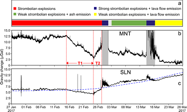
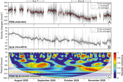
Abstract |
We present results from a mini‐array of three iGrav superconducting gravimeters (SGs) at Mount Etna. This is the first network of SGs ever installed on an active
volcano. Continuous gravity measurements at active volcanoes are mostly accomplished with spring gravimeters that can be operated even under harsh field conditions.
Nevertheless, these instruments do not provide reliable continuous measurements over periods longer than a few days due to the instrumental drift and artifacts
driven by ambient parameters. SGs are free from these instrumental effects and thus allow to track even small gravity changes (1–2 μGal) over a wide range of time
scales (minutes to months). However, SGs need host facilities with main electricity and a large installation surface, implying that they cannot be deployed in
close proximity to the active structures of tall volcanoes. At Mount Etna the three iGrav SGs were installed at distances from the summit active craters ranging
between 3.5 and 15 km. Despite the relatively unfavorable position of the installation sites, we show that these instruments can detect meaningful (i.e.,
volcano-related)changes that would otherwise remain hidden, like, for example, the weak gravity signature (within a few μGal) of gas buildup at intermediate
depth in the plumbing system of Etna, during noneruptive intervals. Our results prove that iGrav SGs are powerful tools to monitor and study active volcanoes
and can provide unique information on the bulk processes driving volcanic activity. |
|
|
|
|
|
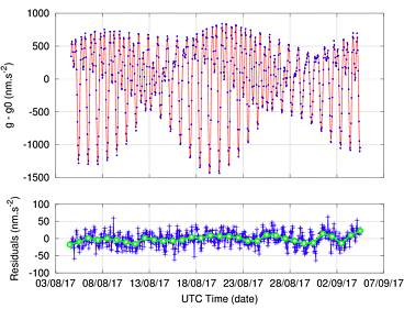
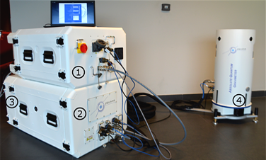
Abstract |
Gravimetry is a well-established technique for the determination of sub-surface mass distribution needed in several fields of geoscience, and various types of gravimeters have been developed over
the last 50 years. Among them, quantum gravimeters based on atom interferometry have shown toplevel performance in terms of sensitivity, long-term stability and accuracy. Nevertheless, they have
remained confined to laboratories due to their complex operation and high sensitivity to the external environment. Here we report on a novel, transportable, quantum gravimeter that can be operated
under real world conditions by non-specialists, and measure the absolute gravitational acceleration continuously with a long-term stability below 10 nm.s^−2 (1 μGal). It features several technological
innovations that allow for high-precision gravity measurements, while keeping the instrument light and small enough for field measurements. The instrument was characterized in detail and its stability was
evaluated during a month-long measurement campaign. |
|
|
|
|
|
Abstract |
During the past few decades, time-variable volcano gravimetry has shown great potential for imaging subsurface processes at active volcanoes (including some processes that might otherwise remain “hidden”), especially when combined with
other methods (e.g., ground deformation, seismicity, and gas emissions). By supplying information on changes in the distribution of bulk mass over time, gravimetry can provide information
regarding processes such as magma accumulation in void space, gas segregation at shallow depths, and mechanisms driving volcanic uplift and subsidence.
Despite its potential, time-variable volcano gravimetry is an underexploited method,
not widely adopted by volcano researchers or observatories. The cost of instrumentation and the difficulty in using it under harsh environmental conditions is a significant impediment to the exploitation of gravimetry at many volcanoes.
In addition, retrieving useful information from gravity changes in noisy volcanic environments is a major challenge. While these difficulties are not trivial, neither are they insurmountable; indeed, creative efforts in a variety of volcanic
settings highlight the value of time-variable gravimetry for understanding hazards as well as revealing fundamental insights into how volcanoes work.
Building on previous work, we provide a comprehensive review of time-variable volcano
gravimetry, including discussions of instrumentation, modeling and analysis techniques, and case studies that emphasize what can be learned from campaign, continuous, and hybrid gravity observations. We are hopeful that this exploration of
time-variable volcano gravimetry will excite more scientists about the potential of the method, spurring further application, development, and innovation. |
|
|
|
|
|
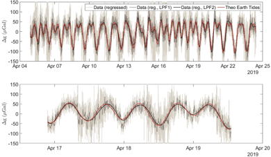
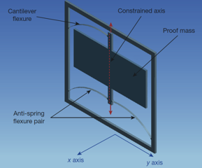
Abstract |
The ability to measure tiny variations in the local gravitational acceleration allows, besides other applications, the detection of hidden hydrocarbon reserves, magma build-up before volcanic eruptions, and subterranean tunnels.
Several technologies are available that achieve the sensitivities required for such applications (tens of microgal per hertz^1/2): free-fall gravimeters, springbased gravimeters, superconducting gravimeters, and atom interferometers.
All of these devices can observe the Earth tides: the elastic deformation of the Earth’s crust as a result of tidal forces. This is a universally predictable gravitational signal that requires both high sensitivity and high stability
over timescales of several days to measure. All present gravimeters, however, have limitations of high cost (more than 100,000 US dollars) and high mass (more than 8 kilograms). Here we present a microelectromechanical system (MEMS)
device with a sensitivity of 40 microgal per hertz^1/2 only a few cubic centimetres in size. We use it to measure the Earth tides, revealing the long-term stability of our instrument compared to any other MEMS device. MEMS accelerometers—found
in most smart phones—can be mass-produced remarkably cheaply, but none are stable enough to be called a gravimeter. Our device has thus made the transition from accelerometer to gravimeter. The small size and low cost of this MEMS gravimeter
suggests many applications in gravity mapping. For example, it could be mounted on a drone instead of low-flying aircraft for distributed land surveying and exploration, deployed to monitor volcanoes, or built into multi-pixel density-contrast
imaging arrays. |
|
|
|
Public project deliverables |
Deliverable 4.1 - Parameters definition for devices design
Mehdi Nikkhoo, Eleonora Rivalta, Daniele Carbone & NEWTON-g consortium
submission date: 05 October 2018
Work Package: WP4 - Data analysis
Lead Beneficiary: Helmholtz-Zentrum Potsdam. Deutsches GeoForschungsZentrum (GFZ)
▶
ZENODO - https://doi.org/10.5281/zenodo.1492735
|
|
|
|
Deliverable 2.1 - Gravity imager design review
Laura Antoni-Micollier, Jean Lautier-Gaud & NEWTON-g consortium
submission date: 30 November 2018
Work Package: WP2 - Development of the gravity imager
Lead Beneficiary: MUQUANS
▶
ZENODO - https://doi.org/10.5281/zenodo.2542583
|
|
|
|
Deliverable 3.1 - Database Structure
Mathijs Koymans, Elske de Zeeuw - van Dalfsen & NEWTON-g consortium
submission date: 27 May 2019
Work Package: WP3 - On-field application
Lead Beneficiary: Koninklijk Nederlands Meteorologisch Instituut
▶
ZENODO - https://doi.org/10.5281/zenodo.3334280
|
|
|
|
Deliverable 5.3 - Dissemination and Exploitation Plan
Daniele Carbone, Letizia Spampinato & NEWTON-g consortium
submission date: 31 May 2019
Work Package: WP5 - Dissemination and outreach
Lead Beneficiary: Istituto Nazionale di Geofisica e Vulcanologia
▶
ZENODO - https://doi.org/10.5281/zenodo.3334306
|
|
|
|
Deliverable 3.2 - Plan for the deployment
Daniele Carbone, Elske de Zeeuw - van Dalfsen, Mathijs Koymans & NEWTON-g consortium
submission date: 20 September 2019
Work Package: WP3 - On-field application
Lead Beneficiary: Koninklijk Nederlands Meteorologisch Instituut
▶
ZENODO - https://doi.org/10.5281/zenodo.4320076
|
|
|
|
Deliverable 2.4 - Quantum device prototype
Laura Antoni-Micollier; Jean Lautier-Gaud; Vincent Menoret & NEWTON-g consortium
submission date: 14 April 2020
Work Package: WP2 - Development of the gravity imager
Lead Beneficiary: MUQUANS
▶
ZENODO - https://doi.org/10.5281/zenodo.4405192
|
|
|
|
Deliverable 2.5 - MEMS device prototype
Karl Toland;
Giles Hammond & NEWTON-g consortium
submission date: 15 May 2020
Work Package: WP2 - Development of the gravity imager
Lead Beneficiary: MUQUANS
▶
ZENODO - https://doi.org/10.5281/zenodo.4405225
|
|
|
|
Deliverable 3.3 -
On-field infrastructures
Alfio Messina; Danilo Contrafatto; Daniele Carbone & NEWTON-g consortium
submission date: 06 June 2020
Work Package: WP3 - On-field application
Lead Beneficiary: Istituto Nazionale di Geofisica e Vulcanologia (INGV)
▶
ZENODO - https://doi.org/10.5281/zenodo.4405239
|
|
|
|
Deliverable 4.2 -
Data mining tools
F. Cannavň; M. Koymans; D. Carbone;
E. Rivalta; M. Nikkhoo; E. De Zeeuw-Van Dalfsen & NEWTON-g consortium
submission date: 7 September 2020
Work Package: WP4 - Data analysis
Lead Beneficiary: Helmholtz-Zentrum Potsdam, Deutsches GeoForschungsZentrum (GFZ)
▶
ZENODO - https://doi.org/10.5281/zenodo.4405421
|
|
|
|
Deliverable 4.3 -
Physical models of relevant processes
E. Rivalta; M. Nikkhoo; D. Carbone & NEWTON-g consortium
submission date: 28 October 2020
Work Package: WP4 - Data analysis
Lead Beneficiary: Helmholtz-Zentrum Potsdam, Deutsches GeoForschungsZentrum (GFZ)
▶
ZENODO - https://doi.org/10.5281/zenodo.7271568
|
|
|
|
Deliverable 3.4 -
Deployment of the system
Laura Antoni-Micollier; Jean Lautier-Gaud; Karl Toland; Daniele Carbone; Vincent Ménoret; Elske de Zeeuw - van Dalfsen & NEWTON-g consortium
submission date: 31 October 2020
Work Package: WP3 - On-field application
Lead Beneficiary: Koninklijk Nederlands Meteorologisch Instituut (KNMI)
▶
ZENODO - https://doi.org/10.5281/zenodo.7271661
|
|
|
|
Deliverable 4.4 -
Pilot phase of data analysis
Mathijs Koymans; Daniele Carbone; Elske de Zeeuw - van Dalfsen & NEWTON-g consortium
submission date: 24 October 2022
Work Package: WP4 - Data analysis
Lead Beneficiary: Koninklijk Nederlands Meteorologisch Instituut (KNMI)
▶
ZENODO - https://doi.org/10.5281/zenodo.7271733
|
|
|
|
Deliverable 4.5 -
Data usage for hazard analysis
Valentin Freret-Lorgeril; Luigi Passarelli; Costanza Bonadonna; Eleonora Rivalta; Mehdi Nikkhoo; Daniele Carbone; Corine Frischknecht & NEWTON-g consortium
submission date: 25 October 2022
Work Package: WP4 - Data analysis
Lead Beneficiary: University of Geneva (UNIGE)
▶
ZENODO - https://doi.org/10.5281/zenodo.7271957
|
|
|
|
Software |
|
Gravity changes due to point triaxial sources
This package contains MATLAB functions for calculating gravity changes associated with triaxial volumetric sources of expansion, namely, the point Compound Dislocation Model
(point CDM) and point Ellipsoidal Cavity Model (point ECM) in a uniform elastic half-space. The functions implement the
Nikkhoo and Rivalta (2022a) analytical solutions.
▶
DOWNLOAD |
|
|
|
The finite ellipsoid cavity model
This package contains MATLAB functions for calculating surface deformations (displacements, strains, tilts) and gravity changes caused by uniformly-pressurized finite triaxial
ellipsoidal cavities, namely, the finite Ellipsoidal Cavity Model (finite ECM) in a uniform elastic half-space. The functions implement the
Nikkhoo and Rivalta (2022b) quasi-analytical solutions.
▶
DOWNLOAD |
|
|